Many of our guests come to enjoy the beautiful Shropshire Countryside and we are lucky to have a very active local Footpath Association who keep the paths in good condition and also produce a series of local walks leaflets, numbering 24 at present. All the leaflets can be downloaded from their very informative website, www.cmfa.co.uk where there are also links to the Outdooractive website where versions of the routes can be downloaded to your phone.
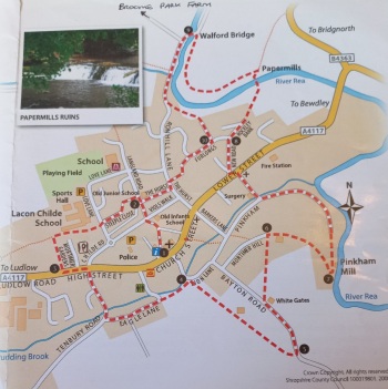
The first walk I have chosen to highlight is Walk 8 - The Cleobury Wiggle. This is described as an Easy walk, mainly made up of paths and lanes, with 2 grassy sections which can be muddy in wet weather. There are 3 uphill stretches. The walk in the leaflet starts from St Mary's Church in the centre of the town but if feeling energetic you can start from Broome Park Farm B&B. If taking this option turn left out of our drive and take the lefthand fork in the road along Green Lane. At the bottom of the hill, where the road turns sharply to the right, you will join the published route at point 9.
If you decide to start at the church there is parking on Childe Road or behind the Talbot Hotel. Public toilets are located in the Childe Road carpark or I suggest using the toilets at the Market Hall, adjacent to the church.
Walk Distance: 3 miles, 1.5 hours
1. From St Mary's Church take the path between the Church and the Market Hall, through the churchyard and bearing left between high hedges. (To the right is the old Childe Boys School, built in 1740 from a bequest by Sir William Lacon Childe, who gives his name to the town Secondary School). Cross the road and continue up the hill, with the old junior school to the right. (The infant and junior school was built in 1863, remaining in use to the early 1970s).
2. Turn left down a narrow path between houses. Follow this to end of cul-de-sac and then continue to the road, opposite the current Secondary school. Cross to take the footpath opposite, with the school fencing on the right. At the end of the school buildings there is a gap in the lefthand side with a few steps down and the path continues to the main Ludlow Road.
3. Cross using the pedestrian crossing and continue down the road, past the Co-Op to the next junction where you will turn right onto Tenbury Road. Where the road turns to the right there is a path to the left, Eagle Lane. At the bottom of the slope, where the path starts to go up to the left, go over the stile. Continue forward alongside gardens to a kissing gate.
4. Go uphill, away from the town to a seat at the top and a great view back over Cleobury. Continue forward in the same direction, across a field with converted farm buildings on your left. Once over the next stile turn left down a track, through a farm gate and onto the Bayton Road.
5. Turn left along the road, passing one stile on the right, after about 150 metres, continue for about 5 minutes, to a house, Whitegates, then a stile on the right. Go over the stile and diagonally left across a field to stable buildings, over a stile and then through a gate to a track.
6. Turn right along this track and continue to the right of a bungalow as it becomes a grassy path. Continue downhill through a gate to Pinkham.
7. Go left along the lane, passing the renovated old mill on the right. At the top of the lane, with the derilict old medical centre opposite, turn right and rejoin the main Ludlow Road at the top of the hill. Turn left and shortly, cross the road and turn right down New Road. As the road turns left take slight right to Rockley Bank.
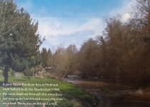
8. At the end take the footpath which enters a field and goes downhill, through a kissing gate. At the bottom of the hill cross the footbridge over the River Rea. Turn left and with the river on your left, pass the ruins of the Papermills. (Papermaking was a major local industry in the 19th century. The papermill burnt down in 1885). Continue through the field, following the line of the river to a gate and then a footbridge on the left.
9. Cross back over the river at Walfords Bridge and stay left, with the river on your right. This is where you join if walking from Broome Park and where you turn right and walk up the hill to return to the farm. Otherwise continue to the left and start the steep climb up Ron Hill. Halfway up there is a footpath to the left, take this route, along Jacobs Ladder, and climb the steps to Furlongs Close.
10. At the junction with Furlongs Road turn right then as the road bends to the right continue straight into the cul-de-sac and take the footpath in the top lefthand corner. At the end, turn left onto the Hurst, then right to continue on the Hurst. You will again pass the old junior school on your right. At the end turn left to retrace your steps back to the church.